
Fichier:Weather-related traffic collision on the Kansas Turnpike.JPG
Pas de plus haute résolution disponible.
Weather-related_traffic_collision_on_the_Kansas_Turnpike.JPG (640 × 480 pixels, taille du fichier : 84 kio, type MIME : image/jpeg)
| Ce fichier et sa description proviennent de Wikimedia Commons. | Accéder au fichier sur Commons |
Erreur : l’attribut name des indicateurs d’état de la page ne doit pas être vide.
Description
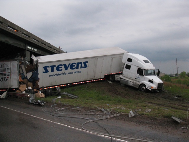
| Description |
English: A traffic collision on the Kansas Turnpike in Butler County, Kansas, initiated by power lines being blown across the Turnpike due to severe thunderstorm winds. |
| Date | |
| Source | http://www.crh.noaa.gov/images/ict/wxstory/2010/buem1.JPG |
| Auteur | Butler County Emergency Management |
Conditions d’utilisation
This image is in the public domain because it was stored on the web servers of the U.S. National Weather Service. NWS-created images are automatically public domain in the U.S. since the NWS is a part of the U.S. government. However, the NWS sites also host non-NWS images which have been submitted by individuals: these are generally shown as "Courtesy of ...". Such images have explicitly been released to the public domain by the copyright owner as part of the upload process.
As stated at https://www.weather.gov/fsd/disclaimer: "By submitting images, you understand that your image is being released into the public domain. This means that your photo or video may be downloaded, copied, and used by others." Thus, all* images on NWS servers are public domain (including "Courtesy of ..." and “Photo by ...” images) unless specifically stated otherwise through a copyright (©) watermark.
*A deletion discussion in November 2023 ruled that Getty Images on the web servers of NWS, are to be considered copyrighted, even without a copyright (©) watermark and are the sole exception to this rule.
|
Historique du fichier
Cliquer sur une date et heure pour voir le fichier tel qu'il était à ce moment-là.
| Date et heure | Vignette | Dimensions | Utilisateur | Commentaire | |
|---|---|---|---|---|---|
| actuel | 16 février 2011 à 15:46 | | 640 × 480 (84 kio) | Ks0stm | {{Information |Description ={{en|1=A traffic collision on the Kansas Turnpike initiated by power lines being blown across the Turnpike due to severe thunderstorm winds.}} |Source =http://www.crh.noaa.gov/images/ict/wxstory |
Utilisation du fichier
La page suivante utilise ce fichier :
Usage global du fichier
Les autres wikis suivants utilisent ce fichier :
- Utilisation sur fr.wikipedia.org