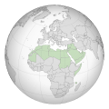
Fichier:Arab league orthographic NED 50m.svg
Le contenu de la page n’est pas pris en charge dans d’autres langues.
Apparence
Une page de Wikiversité, la communauté pédagogique libre.

Taille de cet aperçu PNG pour ce fichier SVG : 550 × 550 pixels. Autres résolutions : 240 × 240 pixels | 480 × 480 pixels | 768 × 768 pixels | 1 024 × 1 024 pixels | 2 048 × 2 048 pixels.
Fichier d’origine (Fichier SVG, nominalement de 550 × 550 pixels, taille : 350 kio)
| Ce fichier et sa description proviennent de Wikimedia Commons. | Accéder au fichier sur Commons |
Erreur : l’attribut name des indicateurs d’état de la page ne doit pas être vide.
Description
| DescriptionArab league orthographic NED 50m.svg |
English: A map of the hemisphere showing the Arab League, centred on Libya. using an orthographic projection |
| Date |
novembre 2009 4 mars 2012 (last version uploaded) |
| Source | Created using Grey-green orthographic projections maps and Gringer's Perl script with Natural Earth Data (1:50m resolution, simplified to 0.25px). |
| Auteur | User:Lexicon (with modifications by others) and Reisio at en.wikipedia / Later version(s) were uploaded by Gringer at en.wikipedia. |
| SVG information InfoField | Le code de ce fichier SVG n'est pas valide en raison de 2 erreurs. |
Conditions d’utilisation
| Public domainPublic domainfalsefalse |
| Cette œuvre a été placée dans le domaine public par son auteur, Reisio sur Wikipédia anglais. Ceci s’applique dans le monde entier. Dans certains pays, ceci peut ne pas être possible ; dans ce cas : Reisio accorde à toute personne le droit d’utiliser cette œuvre dans n’importe quel but, sans aucune condition, sauf celles requises par la loi.Public domainPublic domainfalsefalse |
| Public domainPublic domainfalsefalse |
| Cette œuvre a été placée dans le domaine public par son auteur, Gringer sur Wikipédia anglais. Ceci s’applique dans le monde entier. Dans certains pays, ceci peut ne pas être possible ; dans ce cas : Gringer accorde à toute personne le droit d’utiliser cette œuvre dans n’importe quel but, sans aucune condition, sauf celles requises par la loi.Public domainPublic domainfalsefalse |
Journal des téléversements d’origine
La page de description originale était ici. Tous les noms d'utilisateur qui suivent se rapportent à en.wikipedia.
- 2011-02-17 23:20 Gringer 550×550 (357596 bytes) using Natural earth data, easier to customise, recentred to Libya
- 2010-09-25 05:38 Reisio 550×550 (437253 bytes) {{Information |Description={{en|Arab_League_(orthographic_projection)}} |Source=[[Grey-green orthographic projections maps]] |Date=2009-11 |Author=[[:en:User:Lexicon|]] (with modifications by others) |Permission={{PD-self}} |other_versions= }}
العربية: الرجاء، قراءة الميثاق.
বাংলা: দয়া করে, রীতিনীতিটি পড়ুন।
Deutsch: Bitte lies die Konventionen.
English: Please, read the conventions.
Español: Por favor, lea las convenciones.
Filipino: Paki-basa ang mga kumbensyon.
Français : S'il vous plaît, lisez les conventions.
हिन्दी: कृपया सभागमों को पढ़ लें.
Bahasa Indonesia: Silakan, baca konvensi.
Italiano: Si prega di leggere le convenzioni.
日本語: 規約をご確認ください。
ქართული: გთხოვთ, გაეცნოთ კონვენციებს.
Македонски: Ве молиме, прочитајте ги општоприфатените правила.
Português: Por favor, leia as convenções.
Русский: Пожалуйста, прочитайте соглашения.
Tagalog: Paki-basa ang mga kumbensyon.
Українська: Будь ласка, прочитайте конвенції.
Tiếng Việt: Hãy đọc công văn trước khi đăng.
中文(繁體):請檢視常規
中文(简体):请查看常规
| World maps |
|---|
Africaहिन्दी: अफ्रीका
ქართული: აფრიკა.
Eastern Africaहिन्दी: पूर्वी अफ्रीका
Southern Africa
Central Africa
Northern Africa
Western Africa
Americasქართული: ამერიკა.
हिन्दी: अमेरिका
North Americaहिन्दी: उत्तरी अमेरिका
Central America
Caribbean
South Americaहिन्दी: दक्षिण अमेरिका
Asiaहिन्दी: एशिया (जम्भूद्वीप)
ქართული: აზია.
Português: Ásia.
Українська: Азія.
Eastहिन्दी: पूर्वी एशिया
ქართული: აღმოსავლეთი აზია.
Português: Ásia Oriental.
Українська: Східна Азія.
Centralहिन्दी: मध्य एशिया
ქართული: ცენტრალური აზია.
Português: Ásia Central.
Українська: Центральна Азія.
SoutheastFilipino: Timog-silangang Asya.
हिन्दी: दक्षिण-पूर्वी एशिया
Bahasa Indonesia: Asia tenggara
ქართული: სამხრეთ-აღმოსავლეთი აზია.
Português: Sudeste Asiático.
Tagalog: Timog-silangang Asya.
Українська: Південно-Східна Азія.
Southहिन्दी: दक्षिण एशिया (भारतीय उपमहाद्वीप)
ქართული: სამხრეთი აზია.
Português: Sul da Ásia.
Українська: Південна Азія.
Westernहिन्दी: पश्चिमी एशिया
ქართული: დასავლეთ აზია.
Português: Sudoeste da Ásia.
Українська: Передня Азія.
Europeहिन्दी: यूरोप
ქართული: ევროპა.
Português: Europa.
Română: Europa.
Русский: Европа.
Українська: Європа.
Countries
Oceaniaहिन्दी: ओशिआनिया
ქართული: ოკეანეთი.
Português: Oceania.
Українська: Океанія.
Intercontinentalहिन्दी: अंतर्महाद्वीपिय
ქართული: კონტინენთშორისი.
Português: Intercontinental.
Українська: Міжконтинентальні.
HistoricalEnglish: Unions, Organizations, Kingdoms, Empires
Español: Uniones, Organizaciones, Reinos, Imperios
Filipino: Mga Unyon, Organisasyon, Kaharian, Imperyo
Français : Unions, Organisations, Royaumes, Empires
हिन्दी: संघ, संगठन, राज्य, साम्राज्य व ऐतिहासिक देश
ქართული: გაერთიანებები, ორგანიზაციები, სამეფოები, იმპერიები
Português: Estados extintos.
Tagalog: Mga Unyon, Organisasyon, Kaharian, Imperyo
Українська: Союзи, Організації, Королівства, Імперії
中文(繁體):聯盟、組織、王國和帝國
中文(简体):联盟、组织、王国和帝国
Subnationalsहिन्दी: उपराष्ट्रीय इकाईयाँ
ქართული: სუბეროვნული ერთეულები.
Português: Entidades subnacionais.
Українська: Субнаціональні утворення.
|
Légendes
Ajoutez en une ligne la description de ce que représente ce fichier
Éléments décrits dans ce fichier
dépeint
image/svg+xml
66742fe545372429fe7c274f50981174baadf90c
357 952 octet
550 pixel
550 pixel
Historique du fichier
Cliquer sur une date et heure pour voir le fichier tel qu'il était à ce moment-là.
| Date et heure | Vignette | Dimensions | Utilisateur | Commentaire | |
|---|---|---|---|---|---|
| actuel | 4 mars 2012 à 19:52 |  | 550 × 550 (350 kio) | Domaina | Without South Sudan |
| 26 avril 2011 à 05:19 |  | 550 × 550 (349 kio) | OgreBot | (BOT): Reverting to the most recent version before uploads (originally uploaded on 2011-02-17 23:20 by Gringer). | |
| 26 avril 2011 à 05:19 |  | 550 × 550 (427 kio) | OgreBot | (BOT): This is the version originally uploaded on 2010-09-25 05:38 by Reisio; storing on commons for archival purposes | |
| 17 février 2011 à 23:24 |  | 550 × 550 (349 kio) | Gringer | {{Information |Description ={{en|1=A map of the hemisphere showing the Arab League, centred on Libya, using an orthographic projection and created using gringer's Perl script with [http://www.naturalearthd |
Utilisation du fichier
Aucune page n’utilise ce fichier.
Usage global du fichier
Les autres wikis suivants utilisent ce fichier :
- Utilisation sur bg.wikipedia.org
- Utilisation sur fr.wikipedia.org
Catégorie cachée :


