
Fichier:U.S. Unified Command Plan Map 2008-12-23.png

Taille de cet aperçu : 776 × 599 pixels. Autres résolutions : 311 × 240 pixels | 622 × 480 pixels | 994 × 768 pixels | 1 280 × 989 pixels | 1 600 × 1 236 pixels.
Fichier d’origine (1 600 × 1 236 pixels, taille du fichier : 1,4 Mio, type MIME : image/png)
| Ce fichier et sa description proviennent de Wikimedia Commons. | Accéder au fichier sur Commons |
Erreur : l’attribut name des indicateurs d’état de la page ne doit pas être vide.
Description
| Description |
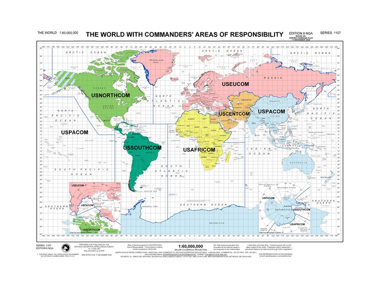
English: The world with commanders' areas of responsibility based on the Unified Command Plan 17 December 2008. (National Geospatial-Intelligence Agency map Edition 8 NGA Series 1107. |
| Date | |
| Source | http://www.defense.gov/pubs/pdfs/MAP12-08.pdf |
| Auteur | National Geospatial-Intelligence Agency |
| Autres versions |
|


Cette PNG image matricielle a été créée avec GIMP.
Conditions d’utilisation
This image is a work of the United States National Geospatial-Intelligence Agency or one of its predecessor agencies. As a work of the U.S. federal government, the image is in the public domain.
|
 |
Historique du fichier
Cliquer sur une date et heure pour voir le fichier tel qu'il était à ce moment-là.
| Date et heure | Vignette | Dimensions | Utilisateur | Commentaire | |
|---|---|---|---|---|---|
| actuel | 28 mai 2009 à 04:57 | | 1 600 × 1 236 (1,4 Mio) | Sv1xv | {{Information |Description={{en|1=The world with commanders' areas of responsibility based on the Unified Command Plan 17 December 2008. (National Geospatial-Intelligence Agency map Edition 8 NGA Series 1107.}} |Source=[[:File:U.S. Unified Command Plan Ma |
Utilisation du fichier
La page suivante utilise ce fichier :