
Fichier:Map Alexander von Humboldt expedition-de.png

Taille de cet aperçu : 800 × 535 pixels. Autres résolutions : 320 × 214 pixels | 640 × 428 pixels | 1 024 × 685 pixels | 1 280 × 856 pixels | 2 844 × 1 903 pixels.
Fichier d’origine (2 844 × 1 903 pixels, taille du fichier : 674 kio, type MIME : image/png)
| Ce fichier et sa description proviennent de Wikimedia Commons. | Accéder au fichier sur Commons |
Erreur : l’attribut name des indicateurs d’état de la page ne doit pas être vide.
Description
| Description |
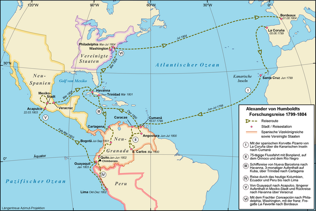
Deutsch: Amerikanische Forschungsreise des Alexander von Humboldt, 1799-1804
English: Alexander von Humboldt's American expedition from 1799-1804 |
| Date | |
| Source |
Own work
Cette PNG image matricielle a été créée avec Inkscape . |
| Auteur | Alexrk |
| Autorisation (Réutilisation de ce fichier) |
Creative Commons : share alike - attribution required |
| Autres versions |
[]
|


|
This map results from a map request to the Kartenwünsche in the Kartenwerkstatt. You can make as well a request for a new map.
|

|
Une version vectorielle de cette image existe, dans le format « SVG ». Si elle n’est pas inférieure, elle devrait être utilisée à la place de la présente version pour des affichages en plus grandes dimensions ou nécessitant une meilleure résolution.
File:Map Alexander von Humboldt expedition-de.png → File:Map Alexander von Humboldt expedition-de.svg
Pour plus d’informations sur les images vectorielles, consultez la page de transition de Commons vers le format SVG. Voir aussi les informations à propos de la manière dont le logiciel MediaWiki gère les images au format SVG. |
 |
Conditions d’utilisation
Moi, en tant que détenteur des droits d’auteur sur cette œuvre, je la publie sous la licence suivante :
Ce fichier est disponible selon les termes de la licence Creative Commons Attribution – Partage dans les Mêmes Conditions 2.5 Générique
- Vous êtes libre :
- de partager – de copier, distribuer et transmettre cette œuvre
- d’adapter – de modifier cette œuvre
- Sous les conditions suivantes :
- paternité – Vous devez donner les informations appropriées concernant l'auteur, fournir un lien vers la licence et indiquer si des modifications ont été faites. Vous pouvez faire cela par tout moyen raisonnable, mais en aucune façon suggérant que l’auteur vous soutient ou approuve l’utilisation que vous en faites.
- partage à l’identique – Si vous modifiez, transformez, ou vous basez sur cette œuvre, vous devez distribuer votre contribution sous la même licence ou une licence compatible avec celle de l’original.
Historique du fichier
Cliquer sur une date et heure pour voir le fichier tel qu'il était à ce moment-là.
| Date et heure | Vignette | Dimensions | Utilisateur | Commentaire | |
|---|---|---|---|---|---|
| actuel | 7 juillet 2009 à 09:08 | | 2 844 × 1 903 (674 kio) | Cäsium137~commonswiki | repair border |
| 7 juillet 2009 à 09:01 |  | 2 844 × 1 862 (670 kio) | Cäsium137~commonswiki | printable scale | |
| 28 mai 2009 à 16:42 |  | 1 200 × 803 (376 kio) | Alexrk | Daten berichtigt | |
| 3 avril 2008 à 14:44 |  | 1 200 × 803 (376 kio) | Alexrk | Reiseroute anhand Koordinaten aus AvH Reisejournal verändert | |
| 21 mars 2008 à 13:16 |  | 1 200 × 803 (377 kio) | Alexrk | ||
| 19 mars 2008 à 16:03 |  | 1 200 × 803 (372 kio) | Alexrk | {{Information |Description={{de|Amerikanische Forschungsreise des Alexander von Humboldt, 1799-1804}} {{en|Alexander von Humboldt's American expedition from 1799-1804}} |Source=Own work<br/>Topographic map: vmap0 (Vector Map Level 0), Dates and Positions: |
Utilisation du fichier
La page suivante utilise ce fichier :
Usage global du fichier
Les autres wikis suivants utilisent ce fichier :
- Utilisation sur de.wikipedia.org
- Utilisation sur hu.wikipedia.org
- Utilisation sur no.wikipedia.org
- Utilisation sur sv.wikipedia.org